Tour of California 2010: stage 3?
Steve Hill has proposed a preliminary route for stage 3 of the 2010 Tour of California. Check out his map here.
However, this prediction is, well, a bit dull. Basically repeating what was done in 2009 with the exception of the crossing of the Golden Gate Bridge from Sausalito, We already know that there will be an extra climb on this year's route. This one actually has one less climb, omitting the climb out of Sausalito.
So I propose an alternate. It adds only 8 km to Steve's route, from 194 km to 202 km. But it's more a quality thing than a quantity thing.
Here's my map.
Steve's route has riders turning right at the top of Tunitas Creek Road, climbing briefly on Skyline Blvd. before descending to Highway 84, then descending 84 and continuing the final 10 km of that road to the coast. Yawn....
Instead I propose they cross Skyline at the top of Tunitas, descend technical Kings Mountain Road, turn right on Highway 84, left on Portola Valley Road, right at the intersection with Sand Hill Road, then right on Old La Honda Road.
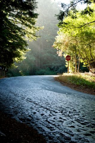
the top of Old La Honda Road on the day of the Low-Key Hillclimb this year (Josh Hadley photo)
Local weekend warriers have been speculating for decades about what the big boys would do on Old La Honda. For example, I suggested Contador could ride it in 12:35 assuming his same effort he demonstrated at Verbier in the 2009 Tour de France. Well, sorry to disappoint, but at this point in the stage nobody's going to be making a maximal effort up Old La Honda. Indeed, I doubt the present record will fall, which rumor has it is 13:45 by Eric Wohlberg in training. Still, it would be amazing to see the pros riding the road so many of us love.
The only question: will the residents of Woodside feel similarly?
Anyway, back to the stage. After climbing Old La Honda to Skyline, I have them descending the narrow, scenic opposite side to Highway 84. Then they continue from there to the coast and southward, following last year's route.
But then I add an additional twist, one I admit is unlikely. Before climbing Bonny Doon, I have the riders detouring over Swanton Road north of Davenport. Sure, there's a lot of scenic detour options along the route, and the organizers probably prefer to keep it simple. But I couldn't resist on this one: Swanton is so cool. A nice little climb, one which Pro Tour legs will hardly notice, but still some very nice spectator options here. I virtually never pass Swanton by when I'm riding down there.
I don't know when Tour officials will commit to route details. It's a long time before the May date for the race. But if they're listening: give Old La Honda the go. It won't affect the final result, but will be extremely popular among local riders.
However, this prediction is, well, a bit dull. Basically repeating what was done in 2009 with the exception of the crossing of the Golden Gate Bridge from Sausalito, We already know that there will be an extra climb on this year's route. This one actually has one less climb, omitting the climb out of Sausalito.
So I propose an alternate. It adds only 8 km to Steve's route, from 194 km to 202 km. But it's more a quality thing than a quantity thing.
Here's my map.
Steve's route has riders turning right at the top of Tunitas Creek Road, climbing briefly on Skyline Blvd. before descending to Highway 84, then descending 84 and continuing the final 10 km of that road to the coast. Yawn....
Instead I propose they cross Skyline at the top of Tunitas, descend technical Kings Mountain Road, turn right on Highway 84, left on Portola Valley Road, right at the intersection with Sand Hill Road, then right on Old La Honda Road.
the top of Old La Honda Road on the day of the Low-Key Hillclimb this year (Josh Hadley photo)
Local weekend warriers have been speculating for decades about what the big boys would do on Old La Honda. For example, I suggested Contador could ride it in 12:35 assuming his same effort he demonstrated at Verbier in the 2009 Tour de France. Well, sorry to disappoint, but at this point in the stage nobody's going to be making a maximal effort up Old La Honda. Indeed, I doubt the present record will fall, which rumor has it is 13:45 by Eric Wohlberg in training. Still, it would be amazing to see the pros riding the road so many of us love.
The only question: will the residents of Woodside feel similarly?
Anyway, back to the stage. After climbing Old La Honda to Skyline, I have them descending the narrow, scenic opposite side to Highway 84. Then they continue from there to the coast and southward, following last year's route.
But then I add an additional twist, one I admit is unlikely. Before climbing Bonny Doon, I have the riders detouring over Swanton Road north of Davenport. Sure, there's a lot of scenic detour options along the route, and the organizers probably prefer to keep it simple. But I couldn't resist on this one: Swanton is so cool. A nice little climb, one which Pro Tour legs will hardly notice, but still some very nice spectator options here. I virtually never pass Swanton by when I'm riding down there.
I don't know when Tour officials will commit to route details. It's a long time before the May date for the race. But if they're listening: give Old La Honda the go. It won't affect the final result, but will be extremely popular among local riders.


Comments
I like your route though. Do you find bikemap.net better than bikely?
I used BikeMap.net because Steve (SteepHill.tv) had used it. But I like it! It's basically like running directions on Google Maps: you anchor end points, then can insert and drag intermediate nodes, and it dynamically connects them with a "best route", avoiding obvious car direction stuff like highways. I'm not sure how well it would for example handle off-the-map stuff like bike paths: this would require a mixing of road constrained and shortest-distance connections. But I think it probably can.
The profile took hours to appear, but they do a nice job with it.