Climbing Pigeons Bay and Okains Bay Roads
After climbing Long Bay Road on that second ride, I continued along Skyline Road, west towards Hill Top.
Summit Road was absolutely gorgeous. Never flat, it's alternately up and down the whole way as it offers fantastic views of both sides of the ridge. It's reminiscent of Skyline Road in San Mateo and Santa Clara counties of California, Summit Road and Highland Road down near Loma Prieta, and Ridgecrest Boulevard on Mount Tamalpais, or El Camino Ciel above Santa Barbara. Each is gorgeous, each similar yet unique. The pavement on Summit on Banks Peninsula was quality chip-seal, no issues at all, and traffic was light, although a high fraction of the traffic was trucks. It's a rural place, with ranches on either side of the road, ranches taking up much of New Zealand land.
So I passed first the road to Le Bons, then Okains Bay Road, then Pigeon Road, in addition to several "unsealed" roads along the way. But then I emerged finally at Hill Top, the terminus of the "tourist" route from Akaroa to Christchurch.
At Hill Top I descended 75 to Barry's Bay at the water's edge. The descent was fantastic: certainly it could have been taken a lot faster than I did. The roadway is excellent and there's no surprises in the corners, with turns presenting even the slightest challenge well-marked with recommended speed limits. The standard speed limit on even two-lane roads in New Zealand seems to be 100 kph, so any turn which can't be taken this fast is marked thus.
Traffic on 75 can be a bit heavy. It's especially bad if you catch the tour buses. On the descent, however, this isn't a bit issue. The road was certainly empty on my first descent, relatively early in the day for traffic originating in Christchurch.

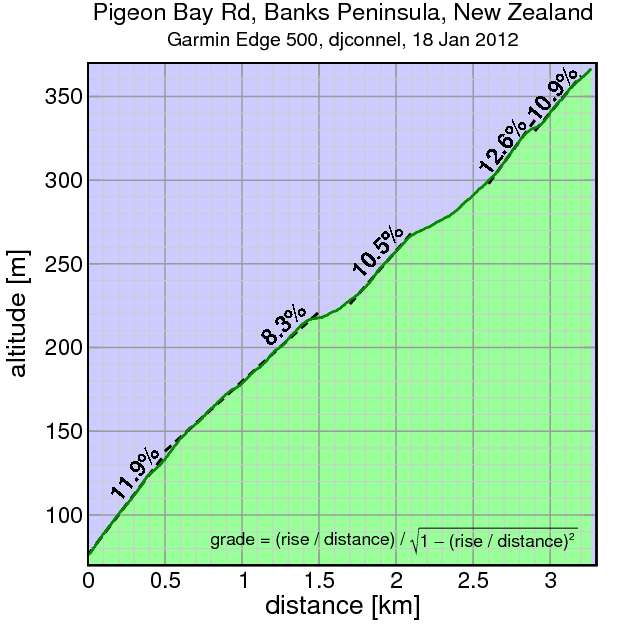
Approaching Devauchelle, I reached my next target: Pigeon Bay Road. Here's the profile. Pigeon Bay has some challenging sections, but since it gains only 290 meters, it passes relatively quickly. But it's actually a bit more than this if you consider all of the roads between 75 and Summit begin at peaks in the undulating Highway 75, and (except for Long Bay) intersect Summit at dips. So there's some climbing to be done before reaching the base of Pigeon Bay.
At the top, I turned left on Summit, returned to Hill Top, then descended 75 again. This time there was substantially more wind and more car traffic. People were beginning to arrive from Christchurch. I even had a vehicle tailgate me a bit to let me know it wanted to pass. It was really the closest thing I'd had to that point to an "incident" in New Zealand. But really it's nothing anti-cyclist; were I in a car at the same speed he'd have done the same thing.
This time after passing Barry's Bay I continued through Devauchelle, climbing again to the next climb in the series, Okains Bay Road. There are two other prominent roads inland between Pigeon Bay and Okains Bay, but they aren't paved routes to Summit.

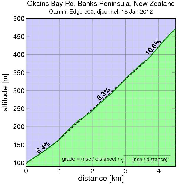
I was getting tired by this point and Okains Bay Road wasn't a very good effort for me. It's longer than Pigeon Bay, gaining around 371 meters. Indeed it seems to go on for quite awhile, Summit always visible above, yet since Summit is descending towards its intersection with Okains Bay, it's never clear how much climbing remains. To make things worse, or perhaps more interesting, the grade increases in segments, so if one isn't aware of this it's easy to think fatigue is winning the battle. In my case, perhaps it was.
But the intersection is only part of the way. There's still over 200 meters of climbing between Okains Bay Road and Long Bay. Tired and hungry, I stopped for a sandwich along this segment, admiring the view while I ate.
Finally I descended Long Bay back to Akaroa. This is the finale of "Le Race", the annual bike race between Christchurch and Akaroa. I can't imagine ending a race on such a steep descent. I'm told there's crashes every year.

Comments