Strava, Garmin Edge, and the top of Old La Honda
The second worst offender in the little investigation I did last post was the "INTEGRATE Performance Fitness OLH Climb". Integrate is a fitness studio in Mountain View so I suspect they did a time trial there to test client fitness. But while the West Alpine climb which resulted in the 48 second error is a bit tricker to debug, this one is fairly clear.
Old La Honda starts with a bridge crossing and finishes 5.2 km later at a stop sign immediately before a ridge road which contains high speed car and motorcycle traffic. While a full stop honestly isn't critical here, at least some attention past the sign is necessary. And it's common for riders to stop past the sign on the dirt shoulder. With manual timing, you start your climb at the bridge (I use the trailing edge) and finish when your front tire crosses the perpendicular line passing through the stop sign. It's all very precise.
But nothing about commercial GPS is "very precise". As I've pointed out, there can easily be a 10 meter error, and in the compromised signal environment among the redwood trees near the top of Old La Honda Road, you're lucky if you do this well. So when defining a segment, it's good to include some error margin. Do not start or finish the segment through which a rider's GPS track, which deviates somewhat from his "true" track, might not pass. When defining segments, I usually move one sample point in at the start and finish of the segment. For one-block segments, for example steep climbs in San Francisco, obviously you can loose a lot of valuable pain this way, so I try to shave it relatively closer. But for a 5.2 km climb like Old La Honda, 10 meters here or there isn't going to change the rankings much. Sure, you will get timing different than you would have gotten with a stop watch, but as I've already described, you can already expect around a 4 second difference anyway.
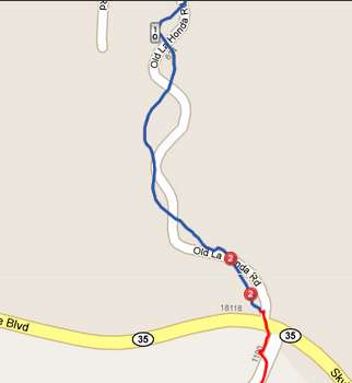
So here's the finish of that INTEGRATE (TM) segment, taken from the Edge 800 data with the identified segment marked in blue:

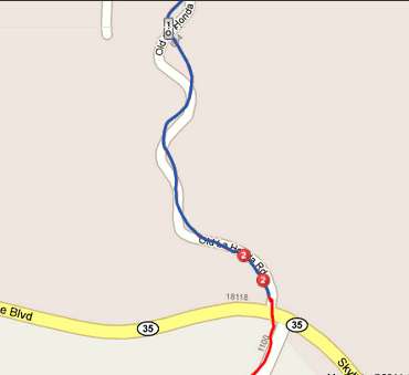
and here's the same section of roadway from the Edge 500 data:

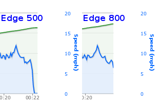
As suspected, the finish is flush right against the edge of Skyline Boulevard. This is bad. Here's the speeds recorded on the two data tracks:

The Edge 800 segment ends just as the speed is falling off. But with the Edge 500, the segment isn't terminated until the rider has been stationary for a considerable duration. Had the segment been terminated just 10 meters early, this problem wouldn't have happened. Fortunately there's other segments for Old La Honda: the INTEGRATE (TM) version defaults to "hidden". The difference in the Low-Key Hillclimb version, which is designed better, is only 8 seconds. That's still a lot, but obviously a lot better than the 25 second difference observed for the INTEGRATE (TM) segment.
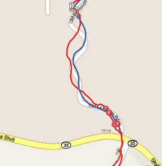
As to why there was a difference in whether the inert portion of the ride was included or not, that's not easy to guess if you compare the trajectories reported by the two units:

Ouch. As I've noted, the top of Old La Honda road isn't very GPS friendly.
Old La Honda starts with a bridge crossing and finishes 5.2 km later at a stop sign immediately before a ridge road which contains high speed car and motorcycle traffic. While a full stop honestly isn't critical here, at least some attention past the sign is necessary. And it's common for riders to stop past the sign on the dirt shoulder. With manual timing, you start your climb at the bridge (I use the trailing edge) and finish when your front tire crosses the perpendicular line passing through the stop sign. It's all very precise.
But nothing about commercial GPS is "very precise". As I've pointed out, there can easily be a 10 meter error, and in the compromised signal environment among the redwood trees near the top of Old La Honda Road, you're lucky if you do this well. So when defining a segment, it's good to include some error margin. Do not start or finish the segment through which a rider's GPS track, which deviates somewhat from his "true" track, might not pass. When defining segments, I usually move one sample point in at the start and finish of the segment. For one-block segments, for example steep climbs in San Francisco, obviously you can loose a lot of valuable pain this way, so I try to shave it relatively closer. But for a 5.2 km climb like Old La Honda, 10 meters here or there isn't going to change the rankings much. Sure, you will get timing different than you would have gotten with a stop watch, but as I've already described, you can already expect around a 4 second difference anyway.
So here's the finish of that INTEGRATE (TM) segment, taken from the Edge 800 data with the identified segment marked in blue:

and here's the same section of roadway from the Edge 500 data:

As suspected, the finish is flush right against the edge of Skyline Boulevard. This is bad. Here's the speeds recorded on the two data tracks:

The Edge 800 segment ends just as the speed is falling off. But with the Edge 500, the segment isn't terminated until the rider has been stationary for a considerable duration. Had the segment been terminated just 10 meters early, this problem wouldn't have happened. Fortunately there's other segments for Old La Honda: the INTEGRATE (TM) version defaults to "hidden". The difference in the Low-Key Hillclimb version, which is designed better, is only 8 seconds. That's still a lot, but obviously a lot better than the 25 second difference observed for the INTEGRATE (TM) segment.
As to why there was a difference in whether the inert portion of the ride was included or not, that's not easy to guess if you compare the trajectories reported by the two units:

Ouch. As I've noted, the top of Old La Honda road isn't very GPS friendly.

Comments
Regards
garmin edge 800